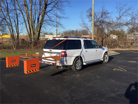
An Infrasense vehicle-based GPR system conducting pavement evaluations

Infrasense GPR Collection in Hawai’i

Earlier this year, Infrasense engineers travelled to the Hawaiian Islands for GPR data collection. Over 2,400 lane-miles of roadways on the islands of O’ahu, Hawai’i, Maui, Kaua’i, Lana’i, and Moloka’i underwent evaluation. Analysis of the GPR data showed pavement layer thicknesses and other underlying conditions. If you have an upcoming project where we can be…

GPR, IR, and HRV Testing In Montana

Infrasense was recently out in Big Sky Country scanning 31 bridge decks primarily located between Missoula and Glendive, Montana. The deck condition evaluations utilized a combination of ground penetrating radar, infrared thermography, rapid automated sounding, and high-resolution visual methods. Targeted locations will also be tested for chloride ion concentration on select decks.

Infrasense Adds To The Team

Infrasense has recently added three new engineers to the staff in anticipation of a busy 2022! Parker Aubin (right) brings his 4 years of geotechnical engineering experience and passion for geophysics on board. Aidan Rolli (left) stuck around after his 2021 summer internship and is now full time, already contributing to a wide range of…

Minnesota Pavement Thickness Survey

Infrasense was recently in Minnesota to carry out a pavement thickness survey using ground penetrating radar.  The results will be used to assist with future pavement design projects.  While there, one of our engineers captured this photo of our survey vehicle under the Milky Way!

Pavement Layer Thickness Survey in Lewis County, New York

Infrasense was in Lewis County, New York this past week completing GPR pavement thickness surveys for select county roads. The surveys will result in continuous pavement layer thickness information which will be validated by cores. To learn more about our pavement structure evaluation capabilities, please visit  https://infrasense.com/pavement-structure-evaluation/ or feel free to email info@infrasense.com with questions…

Infrasense Scans Highway Pavement Outside Atlanta, GA

Last month Infrasense performed a high speed pavement survey on a stretch of Interstate highway outside the transportation hub of Atlanta, Georgia. The purpose of the project was to determine the structure for approximately 17 miles of pavement. Did you know that Georgia contains 15 different Interstate highways? That’s good for tenth most in the…

Infrasense Performs GPR Analysis on 7000 Kilometers of Pavement in Israel

In Spring 2018, Infrasense founder Ken Maser traveled to northern Israel to train a local team on how to collect Ground Penetrating Radar (GPR) data for a network-level pavement survey. For the next seven months, the team collected 7000 km of pavement in 2240 management units. The data was continuously uploaded to Infrasense for quality…

Infrasense Performs in Depth Nondestructive Evaluation of Pavement and Bridges Along I-95 in Southern Connecticut

This past summer, Infrasense surveyed 10 miles of interstate pavement and 23 bridge decks with ground penetrating radar. The objectives of the GPR survey included: Locating the lateral and longitudinal extents of the underlying PCC pavement and full-depth asphalt pavements Providing thicknesses of asphalt and PCC pavement layers Locating and quantifying deterioration in the underlying…

Pavement Structure Evaluations at Locations Throughout Maryland

Infrasense completed a subsurface pavement structure investigation of 18 sections of pavement in Western Maryland using high-speed ground penetrating radar (GPR). The sections were surveyed in both driving directions to obtain continuous structure information for both bound and unbound material layers. The GPR results will be used to supplement Falling Weight Deflectometer (FWD) back-calculations to achieve…