Skip to content
21-G Olympia Avenue, Suite 45, Woburn, MA 01801(781) 281-1686
Search:
Search
Infrasense Inc.
Subsurface Scanning & Mapping
Infrasense Inc.Infrasense Inc.
  • About
  • Services
    • Bridge Deck Scanning
    • Concrete Structure Scanning
    • Pavement Structure Evaluation
    • Utility Locating & Mapping
    • Consulting and Research
    • Aerial Imaging
  • Technology
    • Ground Penetrating Radar
    • Infrared Thermography
    • High-Resolution Imaging
    • Sonic/Ultrasonic Testing
    • Falling-Weight Deflectometer
  • Experience
  • News
  • Contact

Portfolio Archives: Pavement Structure Evaluation

You are here:
  1. Home
  2. Project
ZoomDetails

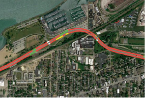
Pavement Structure Type Defined along the Cleveland Memorial Shoreway

Ohio, Pavement Structure EvaluationBy LaurenApril 2, 2018

We used high-speed GPR to map changes in the pavement structure along the Cleveland Memorial Shoreway. The results were presented geospatially with different color line segments corresponding to different pavement structure classifications. Learn More.

ZoomDetails

Density of New HMA Pavement Mapped in FL, MN, CA, ME, NH, and WS

Florida, GPR, Maine, Minnesota, New Hampshire, Pavement Structure Evaluation, WashingtonBy LaurenApril 2, 2018

Infrasense used GPR to map of the relative density of new HMA pavements. This relatively new application is being utilized as a quality assurance measure to compliment recently developed quality control systems, such as Intelligent Compaction

© 2021 Infrasense, Inc.
Go to Top