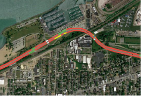
We used high-speed GPR to map changes in the pavement structure along the Cleveland Memorial Shoreway. The results were presented geospatially with different color line segments corresponding to different pavement structure classifications.
We used high-speed GPR to map changes in the pavement structure along the Cleveland Memorial Shoreway. The results were presented geospatially with different color line segments corresponding to different pavement structure classifications.
Infrasense used GPR to map of the relative density of new HMA pavements. This relatively new application is being utilized as a quality assurance measure to compliment recently developed quality control systems, such as Intelligent Compaction
